XPONENTIAL: uAvionix, Kongsberg Geospatial Announce Integrated ADS-B Technology to Improve Drone Safety
Kongsberg Geospatials IRIS UAS situational awareness display now integrates the uAvionix PingStation ADS-B receiver to provide an effective way to monitor drones and airspace.
Kongsberg Geospatial, an Ottawa-based developer of real-time geospatial visualisation software, announced today with uAvionix, a California-based company that creates lightweight ADS-B transponders for unmanned aerial vehicles, that the two companies will be integrating Kongsberg Geospatials IRIS UAS Airspace Situational Awareness Display with uAvionixs PingStation ADS-B receiver.
Kongsberg Geospatial has been providing real-time geospatial and spatial awareness technology to support air traffic management, air defense applications, and unmanned systems for nearly three decades. Their IRIS UAS situational awareness display had its genesis in supporting military UAV flight operations, and was developed to help operators safely pilot UAVs beyond visual line-of-sight (BVLOS).
By integrating the PingStation receiver with the IRIS UAS display, the two companies hope to create a portable and inexpensive solution that would dramatically increase the safety of commercial drone flight operations - especially when operating beyond visual line-of-sight.
PingStation is a lightweight, compact antenna that can quickly be erected on a pole mount, while the IRIS UAS software can be operated on a variety of Ground Control Station displays - or even a Windows Surface tablet. The combined system allows operators to quickly set up and begin tracking the position of their UAV and any nearby aircraft equipped with ADS-B transceivers.
"PingStation is a great fit for the IRIS display," said Ranald McGillis, President of Kongsberg Geospatial. "It provides an efficient and cost-effective way of accurately tracking small unmanned systems, and in combination with the airspace visualization that IRIS UAS provides it will dramatically increase the safety of unmanned flight operations wherever its in use."
Kongsberg Geospatial and uAvionix will be demonstrating the integrated receiver and airspace situational awareness display at the AUVSI Xponential symposium May 8- 11 in Dallas, TX.
###
About Kongsberg Geospatial:
Based in Ottawa, Canada, Kongsberg Geospatial (https://www.kongsberggeospatial.com) creates precision real-time software for mapping, geospatial visualization, and situational awareness. The Companys products are primarily deployed in solutions for air-traffic control, Command and Control, and air defense. Over nearly three decades of providing dependable performance under extreme conditions, Kongsberg Geospatial has become the leading geospatial technology provider for mission-critical applications where lives are on the line. Kongsberg Geospatial is a subsidiary of Kongsberg Defence Systems.
About uAvionix:
uAvionix (http://www.uavionix.com) develops the worlds smallest, lightest and most affordable ADS-B transponder, Ping. uAvionix Ping network system combines hardware, software, and real-time airspace mapping to enable companies to safely and reliably operate drones in the NAS. Based in Palo Alto, uAvionix has gathered a cross-disciplinary team of experts in embedded RF engineering, sUAS operations and compliance, hardware, software, and cloud services.
Featured Product

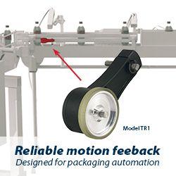
Model TR1 Tru-Trac
The Model TR1 Tru-Trac® linear measurement solution is a versatile option for tracking velocity, position, or distance over a wide variety of surfaces. An integrated encoder, measuring wheel, and spring-loaded torsion arm in one, compact unit, the Model TR1 is easy to install. The spring-loaded torsion arm offers adjustable torsion load, allowing the Model TR1 to be mounted in almost any orientation - even upside-down. The threaded shaft on the pivot axis is field reversible, providing mounting access from either side. With operating speeds up to 3000 feet per minute, a wide variety of configuration options - including multiple wheel material options - and a housing made from a durable, conductive composite material that minimizes static buildup, the Model TR1 Tru-Trac® is the ideal solution for countless applications.
