Data visualization iS the key to smart decisions
mySCADA added some brand new features to its visualization software. Now, mySCADA offers Aggregated data logging, Trend customization, Advanced component library, adding GIS maps directly into the project, Compatibility to even more OPC UA servers and much more.
VERSION 7.0.32 RELEASED!
The continuous development based on our customers' needs is driving us to create new features as well as improve the existing ones. And mySCADA is happy to do that. This is why the newest version, 7.0.32, has been released.
Here are some features and improvements we have implemented:
Aggregated Data Logging
This is a brand new feature which allows a user to view trends in their rough data from multiple data sources. The user can create a data log that will show averages, minimums, maximums or create data logs that will aggregate based on the alarm triggers or some other value changes.
New statistics module is beneficial mainly for those who needs to have the general overview and do not care as much about the minutiae.
Trend customization
While building a new project, a lot of features can help. mySCADA developers are aware of that and implemented plenty of new functions that help to customized the projects. These are just a few of them: selecting colours of the grids and axes; text size of each axis; hiding of objects in the project or changing the parameters to modify how it appears within the active area.
Overall these features enable the user to create a customized project depending on customers' visual requirements.
Components
New section in myDESIGNER (tool for project creation) contains elements:
ComboBox ListBox TextBox
which are essential components when designing your Graphical user interface (GUI) with forms or multiple entry. mySCADA provides these components to use in two different scenarios. One is to use the components along with the View Script to achieve the desired functionality. The second usage is as a standalone component connected directly to a PLC or database.
GIS maps
The geographic information system allows the customer to add and use Google maps as a normal map with all its attributes directly in the project. Other added value permits to place a component or other object into the map. The map acts like a Google map so it is able to zoom and move with no consequences.
More about GIS maps here:
https://www.youtube.com/watch?v=00WEwwOdxzE
Improved compatibility
mySCADA developers improved the compatibility with servers especially the Siemens ones. The software now supports even more OPC UA servers.
Speed improvements
- Retrieving data to get the historical one has never been easier thanks to the redesign of data logging. The data logging works now nearly twice as fast.
- In other sections, there have been a lot of speed improvements as well.
The current information about new features and functions of mySCADA are in the updated User Manual (download here: https://www.myscada.org/download/), on our website (https://www.myscada.org/news/) or social networks.
More about this product: https://www.myscada.org/mypro/
Featured Product
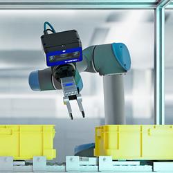
3D Vision: Ensenso B now also available as a mono version!
This compact 3D camera series combines a very short working distance, a large field of view and a high depth of field - perfect for bin picking applications. With its ability to capture multiple objects over a large area, it can help robots empty containers more efficiently. Now available from IDS Imaging Development Systems. In the color version of the Ensenso B, the stereo system is equipped with two RGB image sensors. This saves additional sensors and reduces installation space and hardware costs. Now, you can also choose your model to be equipped with two 5 MP mono sensors, achieving impressively high spatial precision. With enhanced sharpness and accuracy, you can tackle applications where absolute precision is essential. The great strength of the Ensenso B lies in the very precise detection of objects at close range. It offers a wide field of view and an impressively high depth of field. This means that the area in which an object is in focus is unusually large. At a distance of 30 centimetres between the camera and the object, the Z-accuracy is approx. 0.1 millimetres. The maximum working distance is 2 meters. This 3D camera series complies with protection class IP65/67 and is ideal for use in industrial environments.